Beresford’s Lost Villages
When researching churches that we want to visit in the Belchamp region I returned to my page on Belchamp Otten and the lost village of Beauchamp St. Ethelbert.
DMV - Deserted Medieval Villages. Also "Deserted Medieval Settlements", was a reference that I became aware when I
was researching Belchamp Otten. The village/settlement of Belchamp St. Ethelbert was a case in point.
The book "Lost Parish Parish Churchs of Essex" by Andrew Barham references the
DMV papers by Beresford and also many references to Thomas Wright, the primary reference for a lot of my research.
The parish of Northwood is described as being a "lost parish" and there is spoeculation that it was near Mary Hall, in the Belchamps.
The Beresford’s Lost Villages on the University of Hull is now back online. There is
a Wordpress blog:
Top
Northwood
A transcript of the text from Andrew Barham's book. (Coming soon, the text will probably have to be entered by hand)
The OCR of the scan goes here
What the book Essex, by Marcus Crouch says about the Belchamps region:
"
The quality of the landscape defies precise definition. It is open, not high-below 300 feet at its highest, and, although reasonably well provided with good buildings, lacking any architectural feature of the very first quality. It seems to me, nevertheless, to have the quality which one recognizes as Englishness. If I had to show a visitor from overseas a scene which epitomized England I should take him not to Buttermere or to the Avon at Stratford but to the church of Belchamp St Paul and point across the rolling, fertile fields to the distant line of the Stour. Here is a landscape busy with the business of producing food. Having no thought for beauty it contrives, by minding its own business, to be very beautiful.
"
The Blog
The "Beresford's lost villages" - University of Hull
"
This blog accompanies a web page dedicated to the study of Deserted Medieval Settlements. The website was made possible by a generous legacy bequeathed to the University of Hull by Professor Maurice Beresford.
The first launch of the website has concentrated on those settlements identified as being deserted in the seminal publication of 1971, edited by Maurice Beresford and John Hurst entitled ‘Deserted Medieval Villages’. This produced a consolidated list of what were then classed as Deserted Medieval Villages (DMV) in 1968, 2,263 in total. These are villages which appear in documentary sources such as the Domesday Book, medieval tax records and maps, but have since seen a dramatic decline in population to the extent that at some point they have been classed as deserted. The reasons for this desertion are varied, whether from land exhaustion, coastal erosion, a change in land use or the whim of wealthy landowners. Each of the settlements listed as known in 1968 has an individual page which explores a range of datasets for the settlement. In the near future it is hoped that all these sites will also
contain a description of the site and links to further sources. For the time being this is only possible for a few counties.
The future development of the website hopes to add all the settlements that have been identified since 1968 which will at least double the number of settlements listed. This blog will keep you informed of future developments and updates.
The project is based in the Department of History, University of Hull. Project Directors are Dr Helen Fenwick
and Professor Michael Turner. Contact dmv@hull.ac.uk
Unfortunately the website is currently down (Jan 2023). It is hoped to have it re-instated in the future.
Much of the general material from the website can be found on this site – but if you would like to access more detailed information please contact dmv@hull.ac.uk
"
DMV - Deserted Medieval Villages
The blog "Beresford's lost villages" - University of Hull and the study "Deserted Medieval Settlements" (Villages) mentions DMV however there are no listings for Essex on the Wikipedia page.
This is particularly interesting with respect to the history of the Belchamps,
however it is not currently on-line. There (was)is no web-link (URL) on the blog and there is an indication that the project was abandoned due to lack of funds (or interest) in 2014/2015.
The quote above is from the "About" page and the Wordpress site is a "free" site with the pop-up advertisements. The last post was 26 January 2023 saying the the webite would be down from the 31st January 2023.
There is a post from March 2015 saying that research on Essex had been completed and Belchamp St. Ethelbert and Faulkbourne.
Maurice Beresford
The Wikipedia page says:
"
Maurice Warwick Beresford, FBA (6 February 1920 – 15 December 2005) was an English economic historian and
archaeologist specialising in the medieval period.
He was Professor of Economic History at the University of Leeds.
"
The entry from the "Village Explorer"
"
This is a complex place to understand. More usually referred to as Belchamp St Ethelbert this settlement was close
to Belchamp Otten and Belchamp St Paul’s. At one time it was its own parish but all record of this has
disappeared. Added confusion about this settlement has crept in with the church at Belchamp Otten being dedicated
to St Ethelbert, and this site sometimes referred to as St Albrights.
"
"
Through the thirteenth and fourteenth century there are references to Belchamp St Ethelbert and Belchamp St Albrights.
[1] Rodwell records the church as long ago demolished. [2] However the church is located at a distance (TL 8052 4326)
from the grid reference in the 1968 Gazetteer (TL 770 420).
As all records point to the former grid reference it has been adopted here.
There are reports of pottery and stone work being seen in the area, and the field name on the Tithe Map of
the area is Chapel Field. [3]
"
"
The VCH in its transcription of Domesday Book identified one of the Belchamp records in the lands of Count Eustace
in Essex as Belchamp St Ethelbert. [4] However this has not been followed by either the Phillimore edition of the Domesday Book or the English Place-Name Society. [1, 5]
"
"
There is a lack of documentary evidence supporting a large settlement here and the best that can be suggested
at the present time is a deserted hamlet.
"
"
Appears in the Gazetteer of Deserted Medieval Villages known in 1968.
"
References
[1] Reaney, P.H. 1935. The Place-Names of Essex. Cambridge: Cambridge University Press: 448.
[2] Rodwell, W. 1997. Historic Churches: a Wasting Asset. London: Council for British Archaeology Research Report 19:
15.
[3] NMR Pastscape Record No. 382168.
[4] Round, J.H. 1903. ‘Text of the Essex Domesday’, in H.A. Doubleday and W. Page (eds)
A History of the County of Essex. Volume 1: 427-578. London: Archibald Constable & Company.
[5] Rumble, A. 1983. Domesday Book Essex. Chichester: Phillimore.
Village Explorer
The Village Explorer application runs best on a computer display:
The Explorer is rendered using the Arcgis maping service. I came across the Arcgis mapping service when I was looking at the Old Maps of Belchamp Walter. The OS maps that you can overlay with the Arcsis satellite background are particularly useful.
As the developer of the Village Explorer says that it is optimized for use on the computer and that it may not work as well on a tablet. (The same can be said about a mobile phone, but this sort of service is not really of much use when seen on a small screen). The same can be said about this website but I am trying to document the village of Belchamp Walter and surrounds, getting the pages to display on all devices and not to
just present maps.
The "Lost" Essex Village - Beauchamp St. Ethelbert
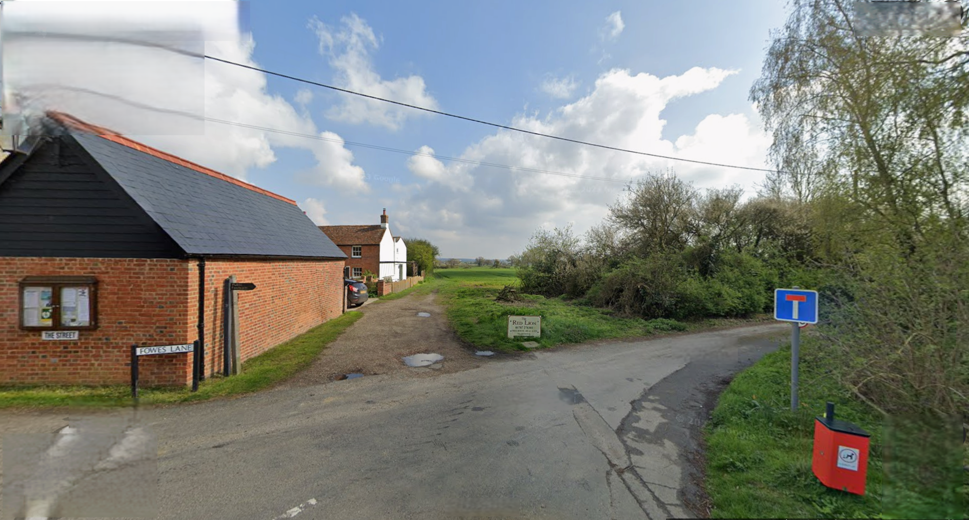
A recent Facebook post on the Belchamps and Surrounding Villages Community Page had a photo similar to below:
This is the corner of Fowes Lane and The Street, Belchamp Otten. The Red Lion pub is to the right on Fowes Lane. It is NOT where the "lost village" of Beauchamp St. Ethelbert is supposed to be according to any of the research that I have found.
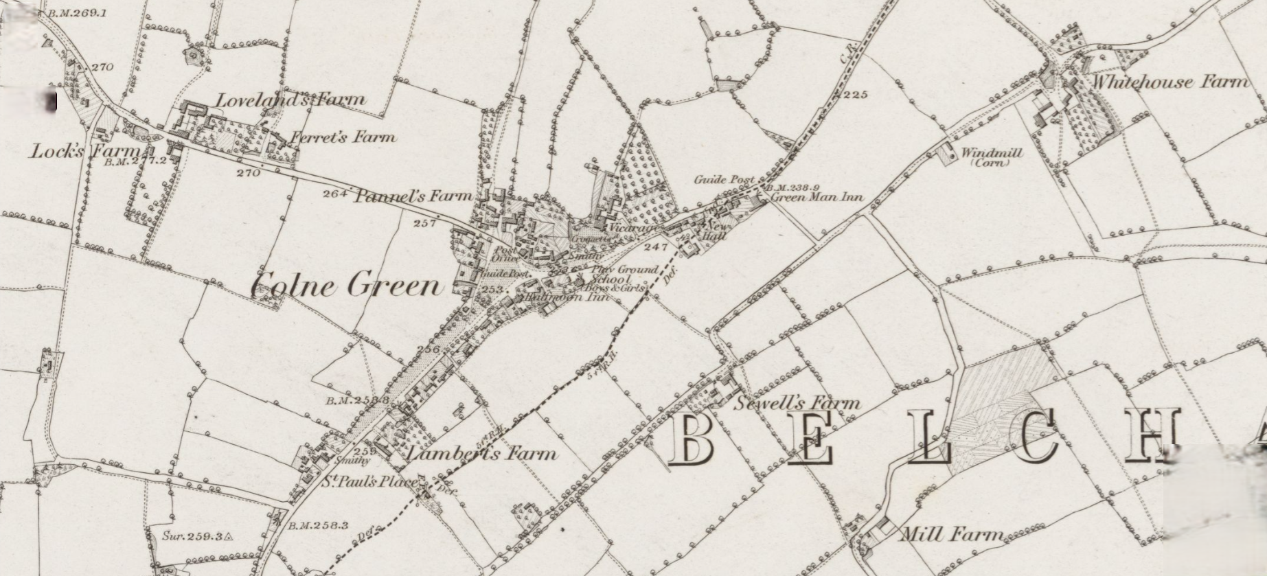
Cole Fair Green are South West of Belchamp St. Paul on the way to Knowl Green. In fact the green at what is now known as Belchamp St. Paul was called Colne Green as shown on the OS map of 31 May, 1880